Tropical Cyclone Zelia
Tropical cyclone Zelia developed off the coast northwest of Broome on February 10 2025. TC Zelia developed to a category 5 severe tropical cyclone (STC) while moving towards the southwest. STC Zelia then turned towards the Western Australia coast on February 14 and made landfall after deterioting to a category 4 STC around 4 pm (AWST) to the north of Port Hedland. STC Zelia then moved inland and deterioted to a tropical low pressure system by midday February 15 2025.

Severe Tropical Cyclone Zelia was a small but very intense cyclone, notable for its rapid development to category 5 off the Pilbara coast of Western Australia. Zelia crossed the coast at category 4 strength near the De Grey River mouth northeast of Port Hedland on 14 February.
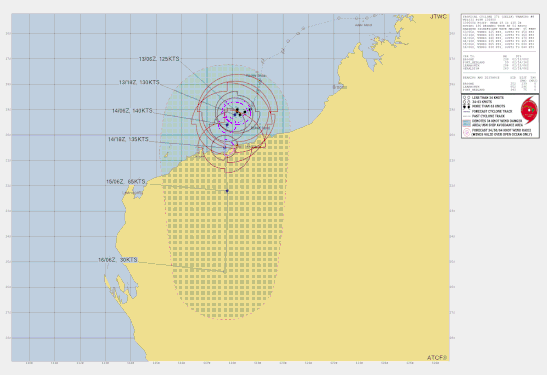
A tropical low (18U) was first tracked on 8 February just off the north Kimberley coast. The low remained weak and moved west-southwest for several days, before turning more southwest late on 10 February. On 11 February the environment became more conducive to development, and the winds around 18U strengthened to gale force. It was named Tropical Cyclone Zelia at 2 am WST 12 February, about 280 kilometres west of Broome.
On the evening of 12 February, Zelia slowed down and became near stationary about 130 kilometres north-northwest of Port Hedland. The ocean in this area was experiencing a marine heatwave and sea surface temperatures were extremely high (31-32°C). Zelia underwent a period of extremely rapid intensification, strengthening to category 5 by around midday WST on 13 February. Zelia spent another day moving slowly and erratically at category 5 strength. Then on the morning of 14 February, it turned southeast and moved towards the coast.
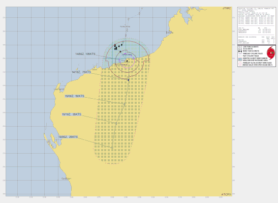
The cyclone weakened slightly as it approached land, but was a high-end category 4 cyclone when it crossed near the De Grey River mouth at 12:30 pm AWST on 14 February. It retained severe tropical cyclone strength through the afternoon as it moved inland, with a discernible eye persisting on radar. During the evening, however, it weakened very rapidly. It was downgraded to a tropical low at 2am WST 15 February near Marble Bar.
The very destructive core of the cyclone did not directly impact any towns. Port Hedland experienced damaging winds in the periphery of the cyclone for about seven hours on 14 February as Zelia approached landfall (maximum gust 120 km/h). Marble Bar experienced gusts up to 109 km/h during the evening as the weakening cyclone tracked 15 kilometres to the west.
Rainfall and flooding caused significant impacts. The event produced record 3-day rainfall totals at De Grey and Pardoo stations, each receiving over 500mm. Numerous other sites in the Pilbara received over 200mm. Record flooding occurred on the De Grey River. The most notable record was observed at Marble Bar where the river peaked at 10.23 m on the morning of 15 February, around 2 metres above the previous record of 8.3 m from 1998. The Great Northern Highway was cut at Coolenar Pool for an extended period of time, isolating Pilbara and Kimberley communities from southern Western Australia. Evacuations from remote communities Warralong and Gooda Binya were conducted during the rising flood. Many secondary roads throughout the inland areas of the Pilbara were affected with many communities isolated as a result.
The closures of ports at Port Hedland (three days), Cape Lambert and Dampier disrupted shipping and combined with disruptions to offshore oil and gas operations resulted in significant economic costs to industry.
Severe Tropical Cyclone Zelia was the fifth tropical cyclone in the Australian region for the 2024/25 season, and the first to make landfall.
From www.bom.gov.au February 2025.